Workshop Report
Bridging the Climate Information Gap
held at Argonne National Laboratory
September 29, 1999
by
John Taylor
Mathematics and Computer Science Division
&
Environmental Research Division
Argonne National Laboratory
This work was supported by the U.S. Department of Energy under Contract W-31-109-Eng-38.
Preface
This document summarizes the discussions held at a one-day workshop at Argonne National Laboratory on the topic of Bridging the Climate Information Gap. The meeting provided an opportunity for open discussion by scientists with an interest in regional climate science and in downscaling global climate model output for use in climate impact assessment for the Midwest and Great Plains. More than forty experts in the fields of regional climate science and high-performance computing attended the meeting and undertook discussions in five working groups. This document provides a record of those discussions; it is not intended to be a comprehensive summary of the field of regional climate science. Comments on the content of this document are welcome.
John Taylor
8 October 1999
In a recent report entitled The Regional Impacts of Climate Change it was concluded that
[T]he technological capacity to adapt to climate change is likely to be readily available in North America, but its application will be realized only if the necessary information is available (sufficiently far in advance in relation to the planning horizons and lifetimes of investments) and the institutional and financial capacity to manage change exists.
The report also acknowledged that one of the key factors that limit the ability to understand the vulnerability of subregions of North America to climate change, and to develop and implement adaptive strategies to reduce that vulnerability, is the lack of accurate regional projections of climate change, including extreme events.1 In particular, scientists need to account for the physical-geographic characteristics (e.g., the Great Lakes, coastlines, and mountain ranges) that play a significant role in the North America climate and also need to consider the feedback between the biosphere and atmosphere.1
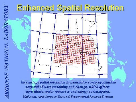
The potential impacts of global climate change have long been investigated based on the results of climate simulations using global climate models with typical model resolutions on the order of hundreds of kilometers. However, assessment of the impacts of climate change at the regional and local level requires predictions of climate change at the 1-10 kilometer scale. Model predictions from global climate models with such high resolutions are not likely to become widely available in the near future.
Accordingly, researchers at Argonne National Laboratory have begun a program to develop and use regional climate models that lead to high-quality projections of regional climate at kilometer resolution; the focus is on the U.S. Midwest. These regional climate projections can be used both at Argonne and by the wider research community to assess the vulnerability of the U.S. Midwest to climate change; in turn, such assessments can be used by policy makers to develop appropriate response strategies.
Regional climate models typically are nested within a global climate model. The figure below illustrates the principle of nesting a regional model within a coarse-resolution global model.
In conjunction with the Argonne effort to develop regional climate models, Argonne scientists are working to establish a Regional Collaborative Climate Center (RCCC). The primary objective in establishing such a center is to link the predictive global climate modeling capability with the impact assessment and policy-making communities. The primary technical challenge is to downscale global climate model output to the regional scale. The focus area is the Midwest and Great Plains region of the United States.
The necessary ingredients for a regional climate collaboration center include the following:
The intended users of the center are climate change researchers and members of the impacts analysis and assessment communities. These users must be able to perform large-scale processing of numerous, diverse, very large, and relatively raw data sets, to distill regionally significant information and to fulfill requests for information by policy makers. We assume most users will bring a high degree of problem-specific knowledge but will possess varying proficiency with computational, data handling, analysis, visualization, and remote access technologies.
In addition to these primary users, the center will engage other users, for example, students and educators at the university as well as K-12 levels studying climate change.
Since many of these users will be accessing the RCCC remotely, the center should be implemented as a virtual facility. The center should support a mix of computation and data access for unique runs and should be transparent with regard to how and where operations are performed, while ensuring adequate performance and appropriate levels of authentication and security.
The planned focus of efforts at the RCCC is as follows:
Outreach is intended to play a central role in the climate center activities. At Argonne we are particularly interested in assisting the scientific community working on Midwest and Great Plains climate issues. Accordingly, we arranged a meeting at Argonne National Laboratory entitled "Bridging the Climate Information Gap." The meeting provided an opportunity for open discussion by scientists with an interest in studying regional climate science and in downscaling global climate model output for use in climate impact assessment for the Midwest and Great Plains. Specifically, the purpose of the meeting was threefold:
Approximately forty researchers from laboratories and universities nationwide attended the workshop. The participants were divided into five working groups, as follows (the chairpersons are given in parentheses); for further information, see Appendixes 1 (the workshop schedule), 2 (a list of workshop participants), and 3 (the working group members).
Each working group was asked to address the following points:-
The next section of this document presents the report of each working group. The last section summarizes the results and presents conclusions about Argonne�s role in establishing and operating a regional collaborative climate center for the Midwest.
The Downscaling group identified five areas of long-term research: downscaling methods, uncertainties in regional climate modeling, candidate regional climate models, data management issues, and regional climate runs.
(i) Downscaling methods
It was recognized that two key approaches to downscaling would provide the basis for a Midwest Regional Collaborative Climate Center at Argonne: physically based modeling; and statistical/empirical-based modeling.
Physically based modeling involves the development of regional climate models appropriate to the region of interest. For the Midwest a regional climate must include a set of physical parameterizations for processes associated with the influence of the Great Lakes, land surface parameterizations, improved representation of the planetary boundary layer, and radiative transfer that can take into account the role of particles.
Statistical/empirical-based modeling may also play a role in downscaling global climate model (GCM) output. A wide range of approaches to statistical modeling are available, and their suitability for downscaling over the Midwest needs to be investigated. Statistical-based methods would be limited to a few key climate variables for which adequate data sets of observations were available for calibration purposes. Very few comparisons between statistical/empirical and physically based downscaling have been undertaken to date, and such comparisons will be needed in the long term.
It was also recognized that downscaling could be both linear, in that it distributes the larger scale global climate model averages at a finer scale, and nonlinear, in that the GCM provides the boundary conditions to a regional climate model, which generates a nonlinear downscaling by taking into account the physical, biological, and chemical processes at a much finer scale than the parent GCM.
(ii) Uncertainties in regional climate modeling
The following were identified as key uncertainties that would need to be addressed in the development of a regional climate model for the Midwest:-
A key concern was the quality of the GCM inputs and their role in determining the ability of regional climate models to produce reliable predictions of climate change. Supported by lessons learned from PIRCS (summarized in the box below), the group emphasized the importance of continued development of GCMs in providing improved boundary conditions for regional climate modeling over the Midwest.
Possible candidates to provide the basis for the development of a regional climate model for the Midwest include the following:
The NCAR MM5v3 modeling system was considered the most appropriate basis for commencing development of a new generation of climate models. It was also recognized that considerable experience has already been gained using MM5v2 and RegCM and that model comparisons will play an important role in establishing the uncertainty associated with downscaled climate model predictions. Nevertheless, the group emphasized that performing regional climate simulations at 1-5 kilometer resolution must be regarded as a new research frontier.
In the long term, a wide range of data products will be needed. Examples include the following:
To ensure accessibility, these data sets must be made available over the Web via interactive tools for analysis, display, and downloading.
Achieving the best possible data quality for regional climate simulations will necessitate several tasks:
Current computing resources allocated to regional climate modeling in the United States allow regional climate runs up to 10 years at 50 km resolution, but not on a routine basis. In the long term, the following needs have been identified:-
Given the uncertainties noted above, a wide range of sensitivity studies will be needed in order to evaluate and improve the quality of the downscaled climate projections. This translates into the need for a substantial increase in computing resources available for investigating the performance of regional climate models and for downscaling the output of GCMs.
In the more immediate term, four research goals were deemed feasible and of high priority: downscaling experiments with MM5v3, additional experiments, statistical downscaling, and development of analysis tools.
An initial experiment was proposed that would build on the existing PIRCS effort. Specifically, model runs for the period 1978-1988 have been completed with the RegCM2 and HIRHAM regional climate models for the Midwest at a nominal 50 km resolution. It was recommended that
Sensitivity studies could also be undertaken with and without the OSU land-surface model and with the Grell and KF convective precipitation schemes. Extending the lateral boundary relaxation conditions will also require investigation; it was proposed that this experiment be undertaken using the ARPS model.
The box below summarizes current plans for the development of MM5v3 by NCAR for application to regional climate simulations.
(ii) Additional experiments
The experiment described above could usefully be extended to include additional lateral boundary condition data sets derived from reanalysis projects and global climate models after completion of the first phase of experiments. The following high-priority lateral boundary condition data sets were identified:
Performing ensemble runs was also recognized as an important tool for model evaluation. However, available resources currently limit our ability to undertake ensemble experiments.
A useful first step would be to undertake a comparison of regression, condition models, and neural net approaches commonly applied in statistical downscaling.
Further development of analysis tools for working with the output of regional climate simulations was also identified as a priority for enhancing productivity. It was proposed that useful short-term activities would be to
The Hydrology group identified two major long-term scientific objectives, each of which also has major implications for impact assessment and policy/decision making:
The group also developed a model evaluation strategy that has two key components aimed at an overall assessment of model uncertainties:
To undertake the first activity, the regional model (MM5) must be run for an appropriate Midwest domain, with NCEP, ECMWF, and/or DAO reanalyses providing the lateral boundary forcing. The domain has yet to be defined; but to accomplish the overall goals, it must contain at least one of the Great Lakes. Thus the initial domain will likely cover the upper Midwest region. After appropriate evaluation, the regional model will be forced at the lateral boundaries using a GCM (most likely the NCAR CCM). This is the same global model that will ultimately be used for climate change scenarios.
Two components are involved in the second activity. The first of these addresses questions of historical variability. GCM runs over the past 1000 years (currently being made at NCAR and elsewhere) will provide the boundary forcing, with historically appropriate land-use changes imposed. Examples include 17th-18th century runs with MM5, the medieval warm period from A.D. 1000 to A.D. 1400, and the "Little Ice Age" of the late 1600s. The second element involves study of paleoclimate (i.e., time periods previous to the historical record) for which geologic reconstructions for the upper Midwest are well known. An obvious example is simulations for 3k, 5k, 6k, 7k, 9k BP, for which considerable prior global modeling exists and for which extensive geologic reconstructions have been made.
Ultimately scientists will be moving toward simulations of possible future climatic change (e.g., under an enhanced greenhouse world), so that the two long-term scientific objectives can be realized.
Six other long-term issues meriting future work were identified during the meeting:
Our short-term goals for the next year are aimed at developing and implementing a regional model system that is capable of simulating climate for the upper Midwest, including the Great Lakes. The proposed region has yet to be defined fully, but is likely to be based on the north-central region of GCIP. Focusing on this limited-scale area will enable researchers to take advantage of the tremendous amount of work already being done for this region through GCIP; three members of the Hydrology team (Oglesby, Marshall, and Lapenta) are also current GCIP principal investigators.
The following are needed for model development:
Two factors must be kept in mind as this preliminary regional model run is designed and implemented:
If the necessary model developments are successfully undertaken, researchers should be able during the coming year to make an initial five-year run for the upper Midwest domain, using MM5v3 and the most suitable land surface package, forced by NCEP II.
The Energy group identified five primary objectives: (1) assessing energy consumption and generation scenarios over the next 100 years for the Midwest; (2) developing and collecting greenhouse gas source/sink estimates on a local scale; (3) developing and collecting emission scenarios for precursors of air pollution and aerosols on the local scale; (4) performing assessment calculations to evaluate the impacts of these emissions on climate and the effect of climate change on these estimates; and (5) preparing impact assessments for the regions� air quality, agricultural production, and human health
(i) Energy production/consumption
Development of energy consumption/production scenarios is a crucial task because of the
proposed energy utilities deregulation and the possible decommissioning of aging nuclear energy generation infrastructure that generates a significant portion of the current Midwest energy supply. The choices made for future energy generation could dictate the location of the power plants and, as a result, the emissions of greenhouse gases and air pollution precursors in the region. The group identified potential parties that may be
actively pursuing this task, including some at Argonne. It was agreed that the relevant parties, starting with those located inside Argonne, should be included in future meetings and a discussion started with them immediately. Moreover, in developing and assessing currently available modeling frameworks for estimating regional energy requirements and consumption, consideration should be given to the impact of decisions made on a countrywide and international scale. There should be feedback from these model outputs into the global-scale models, in order to develop realistic assessment scenarios.
(ii) Greenhouse gas budgets
Developing tools for detailed analysis of greenhouse gas emissions and sinks on a local scale was considered a necessary priority for the center. In this context, the center could emulate the work performed by the Iowa Department of Natural Conservation in developing greenhouse gas sink/source estimates to the level of local farms. The focus of the Iowa effort was to develop policies to make that state a net zero greenhouse gas emitter. This type of inventory-making capability should be acquired by the center and a demonstration performed to show that better decision making would result from better tools.
(iii) Integrated assessment modeling
The most effective tool the center could develop to serve users across a broad cross-section of society, from research scientists to policy makers, is an integrated assessment model. These types of models are frequently used in the IPCC assessments on a global scale and integrate across a range of process-scale models representing energy production, consumption, emissions, and impacts of greenhouse gases and pollutants. Such models provide an excellent opportunity to study the feedback between climate and the biosphere, atmospheric trace gas abundance, and the energy production/consumption in various sectors of the economy in an integrated framework. The development of integrated assessment tools is still in its infancy, and the center could make a strong bid for leadership in this area..
(iv) Science issues
Science issues of interest include the impact of further urban sprawl on oxidants and aerosols, effects of land use change on regional climate, and impacts of agricultural practices on climate and chemistry. The relationship between energy use and agriculture, in particular, should be a focus of the center�s science activities. Below is a list of science issues that were discussed:
(v) Modeling tools
The group identified the following process models to evaluate the energy-chemistry-biosphere-climate interactions on a regional scale:
Several of these models are available within the group, and it was decided to examine available options for the remaining modules.
(vi) Uncertainties
The following uncertainties were listed as items for consideration in the regional-scale modeling efforts described above:
(vii) Computing and data storage and handling
The following list of priorities was discussed at the meeting:
In the short term, energy research should focus on GHG budgets and regional-scale assessment models.
(i) GHG budgets
Two activities were identified for immediate consideration:
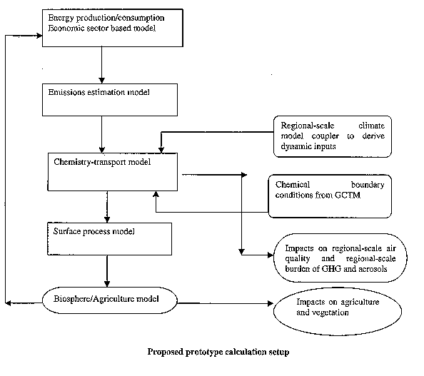
A prototype model calculation was recommended as a first step toward developing a comprehensive integrated assessment model for the regional scale. This calculation should involve development of interfaces between models calculating energy production/consumption based on sector analysis, an emissions calculation model that uses the output from the energy model to compute emissions of pollutants, and GHGs. This calculation in turn would feed into a chemistry-transport model linked to the
regional-scale climate model to drive the model transport. The chemical model boundary conditions would be set from global-scale CTM outputs, by developing couplers between the regional-scale code and the GCTM. The RCTM would be connected to a surface process model with the capability of computing deposition rates and emissions from biosphere. The final step would link this model to a crop-nutrient-cycle model to calculate soil emissions and effects of deposition from the gas phase on the nutrient-cycle
in the soil. The outputs would in turn be fed back to the energy component model to improve the decisions made on energy consumption/production in each sector of the economy, so as to minimize the impacts on the biosphere and air quality. The prototype would function with models readily available, and missing components would be filled with shell interfaces for the prototype calculation.
As a part of this process, the group identified the following issues to be analyzed and summarized in a report to be submitted by the end of next year:
The figure below shows the proposed prototype calculation setup.
Group 4: Planetary Boundary Layer
Long-term goals for the planetary boundary layer (PBL) effort can be considered in three broad categories: service, data products, and research.
Service identifies the potential "customers," a useful consideration before defining research goals. These customers are involved in agriculture, hydrology, urban and regional planning, air pollution meteorology, ecology, economics, and research at a variety of private and government organizations.
Data products associated with the PBL include storm frequency, especially extremes in precipitation amounts; length of the growing season; extremes in winds (e.g., with regard to loading on buildings and soil erosion); extremes in temperature as they affect vegetation and soil freezing depth; and atmospheric stability as it affects the vertical and horizontal transport of trace substances. Parameters most directly involved with many of these data products are surface temperature, near-surface temperature and humidity, the diurnal variation of the PBL height and vertical density stratification, surface energy exchange, and local mesoscale circulations. Processes such as solar irradiance, water drainage, irrigation, and changes in land use patterns must also be considered.
Research necessary to ensure an adequate description of the PBL in regional climate scenarios requires both the accurate simulation or parameterization of PBL processes and the achievement of a sufficiently fine spatial resolution. The daytime PBL over homogeneous terrain with known properties is fairly well understood, but the effects of
surface heterogeneity and of very stable conditions at night remain subjects of research. Models with high spatial and temporal resolution must continue to be developed. These models can be used to develop parameterizations for regional- and large-scale models or be used as nested models in regional-scale models. Also needed are intensive observations using both in situ and remote sensing systems. In addition, long-term
observations are often necessary to examine the full range of conditions that occur throughout the year; data sets need to be made readily available to researchers. Such observations provide information necessary to improve PBL models and parameterizations and can serve as a benchmark for evaluating nested models.
To achieve fine spatial resolution, extensive data bases are needed on surface quantities such as soil moisture, vegetative types, green leaf areas, senescent vegetative coverage, agricultural practices, extent of urbanization, and fractional snow cover. Remote sensing data obtained from satellites provide an important source of such information, especially when used with surface stations for "ground truth." For example, mesoscale models require periodic updates on soil moisture conditions to avoid "drift" in simulate soil moisture content, which is important in affecting evapotranspiration rates and cloud formation, surface temperatures, and atmospheric stability. The nondimensional difference vegetation index, infrared temperature, and microwave surface brightness in the L-band are examples of parameters based on surface radiances detected from satellites that can used to estimate soil moisture content. However, because spatial variability in the surface properties can be large on very fine scales, often less than 200 m in the Midwest and the Great Plains, methods of aggregrating descriptions of surface properties are often necessary to provide effective inputs to regional- and large-scale models. Better methods of describing surface conditions such as aerodynamic surface roughness, surface energy balance components, soil moisture content, and surface temperature averages over scales spanning large changes in surface conditions need to be developed.
Several ongoing research efforts in which progress is possible during the next year or so were identified with regard to PBL processes:
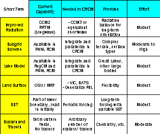
Argonne has been working closely with the NCAR Mesoscale and Microscale Meteorology Division, Pacific Northwest National Laboratory, and a number of collaborating institutions (see http://www.mmm.ucar.edu/mm5/CRCM) to develop a Community Regional Climate Model based on MM5, the fifth-generation Penn State/NCAR Mesoscale Model. The CRCM effort will fold previous MM-based Regional Climate Models (RegCM, PNNL RCM, IFU RegCM) into a single community resource developed and maintained as part of the parallel MM5 community mesoscale model. Many capabilities for long climate-scale regional simulations already exist in MM5, including the ability to run on large distributed SMP-cluster parallel computers. Additional enhancements for regional climate are described in the table below; these include both long-term and short-term efforts.
Such enhancements will require significant computing capabilities. Currently, we estimate that a typical experiment will involve a number of computationally intensive and data-intensive runs of a regional climate model to downscale large global reanalysis or climate model data sets over a period of several months to years. The regional model would be run at significantly higher (and therefore more costly) resolution (3-10 kilometers per grid cell) than the input (50-200 kilometers). To achieve one year�s simulation for a domain 1000 km square, a regional climate model run at 10 km resolution will require 40 Gflop/second sustained performance for 24-hour turnaround and will generate 50 Gbytes of hourly history output. To run the same domain at 3.33 kilometers resolution requires 27 times the performance, 1.1 Tflop/second, and generates 9 times the data volume.
We expect a more complete picture of computing and infrastructure requirements to emerge over time, as a result of interactions and planning with the scientific users,
For the long term, we propose that the RCCC have at least enough dedicated supercomputer resources to support the equivalent of several (5-10) 10-year high-resolution (3 km or less) studies per year. In addition to computational requirements, the center will require multiterabyte data storage and archiving capabilities, presumably in concert within a larger DOE metacomputing infrastructure (e.g., the Earth System Grid project). Also required will be Web-enabled visualization and analysis software and hardware, desktop and workspace remote collaboration tools, network connectivity and bandwidth, quality of service, and secure access to support the virtual concept of the RCCC.
The relatively modest requirements for a short-term (first-year) set of downscaling experiments (see Downscaling section) may be met by purchasing time on resources currently available to participating institutions:
Software resources available to support first-year center prototype goals include the following:
Providing high-resolution regional climate information has long been recognized as critical information necessary for the assessment the impacts of climate change and to develop and implement adaptive strategies to reduce that vulnerability. The discussion, as reported above, provides a concise summary of the many high-priority scientific and technical challenges that must be addressed if region-specific climate information is to be used on a routine basis to assess the potential impacts of climate change on the Midwest. If the challenges identified above are to be addressed, then the development of strong interdisciplinary research programs and research teams that can provide comprehensive coverage of the scientific and technical issues is urgently, and inevitably, needed.
Bridging the Climate Information Gap
Argonne National Laborator
ySeptember 29, 1999
Agenda
7:45 - 8:15AM Shuttle van from Argonne Guest House Entrance to Bldg. 221 Lobby
8:00 - 8:30AM Registration and Travel Reimbursement
Coffee and Rolls
8:30 - 8:40AM Welcome - Rick Stevens, Director MCS
8:40 - 9:00AM Introduction to ANL Regional Climate Group & Meeting Objectives
John Taylor, ANL
9:00 - 10:30AM Working Groups - Long term scientific goals
Downscaling - John Taylor - Bldg. 221-A216
Energy - Rao Kotamarthi and Don Wuebbles - Bldg. 203-C230
Water - Bob Oglesby and Jay Larson - Bldg. 221-A261
PBL - Marv Wesely - Bldg. 203-E142
Computing - Ian Foster and John Michalakes - Bldg. 221-C101
10:30-10:45AM BREAK - Coffee in A216
10:45-11:30AM Working Groups � cont.
11:30 - 12:30PM Plenary Session - Long term scientific goals - Bldg. 221-A216
12:30 - 1:30PM No Host Lunch - Dining Room A in Cafeteria - Bldg. 213
1:30-2:00PM Regionalization Strategies for Climate Change Scenario Development: Perspectives from the IPCC Third Assessment Report (TAR)� Linda Mearns, NCAR
2:00-3:30PM Working Groups - Immediate scientific goals
Downscaling - John Taylor - Bldg. 221-A216
Energy - Rao Kotamarthi and Don Wuebbles - Bldg. 203-C230
Water - Bob Oglesby and Jay Larson - Bldg. 221-A261
PBL - Marv Wesely - Bldg. 203-E142
Computing - Ian Foster and John Michalakes - Bldg. 221-C101
3:30-3:45PM BREAK � Refreshments in A216
3:45-5:00PM Working Groups � cont.
5:00 - 6:00PM Plenary Session - Immediate scientific goals - Bldg. 221-A216
6:00PM Adjourn - Shuttle van from Bldg. 221 Lobby to the Argonne Guest House
Arritt, Raymond
Associate Professor
Iowa State University
3010 Agronomy Hall
Ames, Iowa 50011
515-294-9870
515-294-2619
Carmichael, Gregory
Professor, Center for Global & Regional
Environmental Research & Dept. of Chemical & Biochemical Engrg.
University of Iowa
204 IATL
Iowa City, IA 52240
319-335-3333
319-335-3337
Chen, Fie
Scientist-I
NCAR
3450 Mitchell Lane
Boulder, CO 80301-2260
303-497-8454
303-497-8401
Dudhia, Jimy
Dr., MMM Division
NCAR
P.O. Box 3000
Boulder, CO 80307-3000
303-497-8950
303-497-8171
Evard, Remy
Manager of Advanced Computing Technologies and Networking (ACTN)
Argonne National Laboratory
MCS 221, 9700 S. Cass Avenue
Argonne, IL 60439
630-252-5963
630-252-5986
Foster, Ian
Senior Computer Scientist
Argonne National Laboratory
MCS 221, 9700 S. Cass Avenue
Argonne, IL 60439
630-252-4619
630-252-5986
Grimmond, Sue
Associate Professor
Indiana University
Dept. of Geography, Atm. Science Program
701 E. Kirkwood Ave
Bloomington, IN 47405-7100
812-855-7971
812-855-1661
Hammond, Steve
Head, Computational Science Section
NCAR
1850 Table Mesa Drive
Boulder, CO 80303
303-497-1811
303-497-1286
Jacob, Robert
Research Associate, Dept. of Geophysical Sciences
University of Chicago
5734 S. Ellis Ave.
Chicago, IL 60637
773 834-2788
773 702-9505
Jain, Atul
Dr., Dept. of Atmospheric Sciences
University of Illinois
105 South Gregory Street
Urbana, IL 61801
(217) 333-2128
(217) 244-4393
Johnson, Tom
Director and Professor
Large Lakes Observatory
Univ. of Minnesota-Duluth
Duluth, MN 55812
218-726-8128
218-726-6679
Kotamarthi, Rao
Meteorologist
Argonne National Laboratory
Bldg. 203, J-177
9700 S. Cass Ave.
Argonne, IL 60439
630-252-7164
630-252-5498
Kristovich, David
Professional Scientist
Illinois State Water Survey
Department of Natural Resources and
University of Illinois at Urbana-Champaign
2204 Griffith Drive
Champaign, IL 61820-7495
217-333-7399
217-333-6540
Lapenta, William
Atmospheric Research Scientist
Global Hydrology and Climte Center
NASA
977 Explorer Blvd.
Huntsville, AL 35806
256-922-5834
256-922-5723
Larson, Jay
Earth System Science Interdisciplinary Center
Univ. of Maryland
NASA
Code 910.3 - NASA GSFC
Greenbelt, MD
301-614-6246
301-614-6297
Larson, Sue
Associate Professor
University of Illinois
Dept. of Civil & Environmental Engrg., 3230 Newmark Cel, MC-250 N. Mathews Ave.
Urbana, IL 61801
217-333-0047
217-333-6968
Liang, Xin-Zhong
Assoc. Professional Scientist
Illinois State Water Survey
Department of Natural Resources and
University of Illinois at Urbana-Champaign
2204 Griffith Drive
Champaign, IL 61820-7495
217-244-6864
217-244-0220
Marshall, Susan
University of North Carolina-Charlotte
Department of Geography and Earth Sciences-9201 University City Boulevard
Charlotte, NC 28223
704-547-3498
704-547-3182
Mearns, Linda
Scientist III
NCAR
P.O. Box 3000
Boulder, CO 80307-3000
303-497-8124
303-497-8125
Michalakes, John
Software Engineer/Visiting Scientist
NCAR, MMM Division
3450 Mitchell Lane
Boulder, CO 80301
303-497-8181
Moore, Thomas L.
Geologist
Energy Systems Division
Argonne National Laboratory
9700 South Cass Avenue � Bldg. 362
Argonne, IL 60439
630-252-5856
630-252-9281
Nefedova, Veronika
Postdoctoral Appt
Argonne National Laboratory
MCS 221, 9700 S. Cass Avenue
Argonne, IL 60439
630-252-5666
630-252-5986
Oglesby, Bob
Associate Professor
Purdue University
Dept. of Earth & Atmospheric Sciences
West Lafayette, IN 47906
765-494-9531
765-496-1210
Reilly, Chris
Director, Environmental Reseach
Argonne National Laboratory
ER 203, 9700 S. Cass Avenue
Argonne, IL 60439
630-252-3879
630-252-2959
Rowe, Clinton M.
Associate Professor
University of Nebraska-Lincoln
Dept. of Geosciences, 305C Bessey Hall
Lincoln, NE 68588-0340
402-472-1946
402-472-4917
Salisbury, Chuck
Scientific Programmer
Argonne National Laboratory
9700 S. Cass Avenue
Argonne, IL 60439
630-252-7573
630-252-6104
Schmid, Hans Peter (HaPe)
Assistant Professor
Indiana University
Dept. of Geography, Atm. Science Program
701 E. Kirkwood Ave
Bloomington, IN 47405-7100
812-855-6125
812-855-1661
Shepson, Paul
Professor
Purdue University
1393 Brown Building
West Lafayette, IN 47906
765-494-7441
765-494-0239
Sorbjan, Zbigniew
Res. Assoc. Professor
Marquette University
Dept of Physics
Milwaukee, WI 53201
414-288-7458
414-288-3989
Stevens, Rick
Director, MCS Diviision
Argonne National Laboratory
Bldg. 221, A-209, 9700 S. Cass Ave.
Argonne, IL 60439
630-252-3378
630-252-6333
Taylor, John
Computational Scientist
Argonne National Laboratory
Bldg. 203, C-245, 9700 S. Cass Ave.
Argonne, IL 60439
630-252-4213
630-252-5986
Ting, Mingfang
Assoc Prof. UIUC/FRA at ANL
Argonne National Laboratory
Bldg. 203, J-158, 9700 S. Cass Ave.
Argonne, IL 60439
630-252-1152
630-252-5498
Tobis, Michael
Research Scientist
University of Wisconsin
1225 W. Dayton St.
Madison, WI 53706
608-263-2566
608-249-3321
Wesely, Marv
Senior Meteorlogist
Argonne National Laboratory
Bldg. 203, J-143, 9700 S. Cass Ave.
Argonne, IL 60439
630-252-5827
630-252-7164
Wilhelmson, Bob
Professor of Meteorology
University of Illinois
105 South Gregory Drive
Urbana, IL 61801
217-333-8651
217-244-4393
Wuebbles, Donald
Head, Dept. of Atmospheric Sciences
University of Illinois
105 South Gregory Street
Urbana, IL 61801
217-244-1568
217-244-4393
Xu, Yiwen
Posdoctoral Appt.
Argonne National Laboratory
ER 203, 9700 S. Cass Avenue
Argonne, IL 60439
630-252-6139
630-252-5498
Xue, Ming
Senior Research Scientist
University of Oklahoma
SEC, Rm 1110, 100 E. Boyd
Norman, OK 73019
405-325-6037
405-325-7614